Skip to product information


Yellowstone National Park Hiking Trails GPS Map | Paper & Mobile Adventure Guide
Sale price
$3.00
Regular price
$11.95
Shipping calculated at checkout.
Explore Yellowstone with the Ultimate Hiking Trail Map
America’s First National Park — Trail-Ready, Adventure-Proven
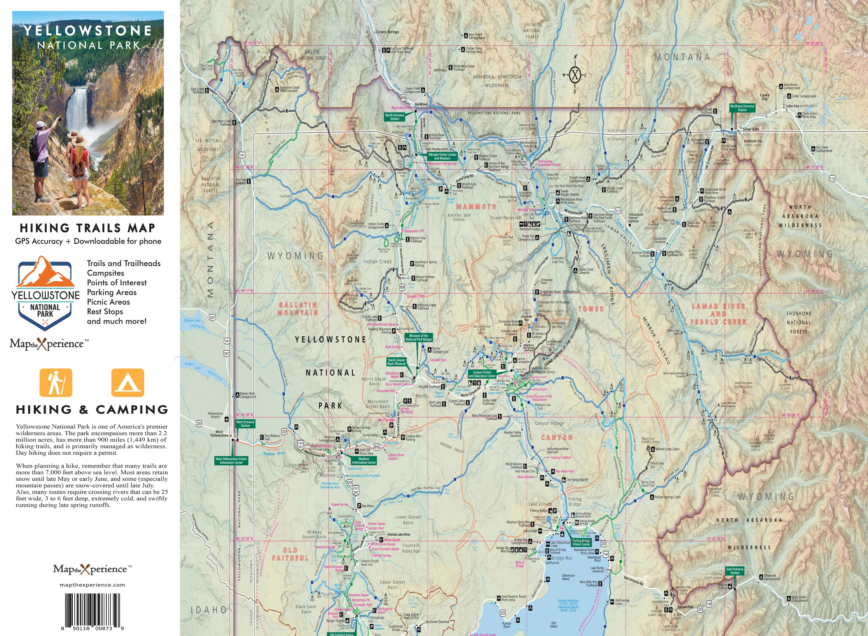
Ready to hike smarter, not harder? The Yellowstone National Park Hiking Trail Map is a large-format, trail-focused guide designed for hikers who want the full picture—before they ever step onto the trail. Covering Yellowstone National Park with clear, high-detail cartography, this map highlights the park’s most iconic hikes, from the panoramic summit of Mount Washburn to the geyser basins near Fairy Falls, the wildlife-rich Lamar Valley, and the rugged backcountry surrounding Yellowstone Lake. Designed by local experts and field-tested on the trail, it helps you plan smarter, hike farther, and explore with confidence.
Built for Real Hiking
Every trail is clearly marked with:
-
Difficulty rating
-
Mileage and elevation gain
-
Scenic highlights and key landmarks
-
Campsites, viewpoints, and geothermal features
Whether you’re planning a family day hike or a multi-day wilderness trek, this map delivers the clarity, confidence, and coverage you need to go deeper.
Why Hikers Love This Map
Choose the right trail at a glance with color-coded difficulty ratings:
-
🟢 Easy – Ideal for families and casual hikers
-
🔵 Moderate – Great for longer distances and elevation gain
-
⚫ Difficult – Built for experienced backcountry explorers
Navigate confidently with distances, elevation profiles, and points of interest clearly laid out, and discover wildlife corridors, scenic overlooks, and lesser-traveled loops beyond the crowded paths.
Field-Tested. Adventure-Ready.
-
36″ × 24″ unfolded for full-park context
-
Folds to 4″ × 8″ for easy storage in packs and gloveboxes
-
Rugged, tear-resistant construction built for wind, rain, and rugged terrain
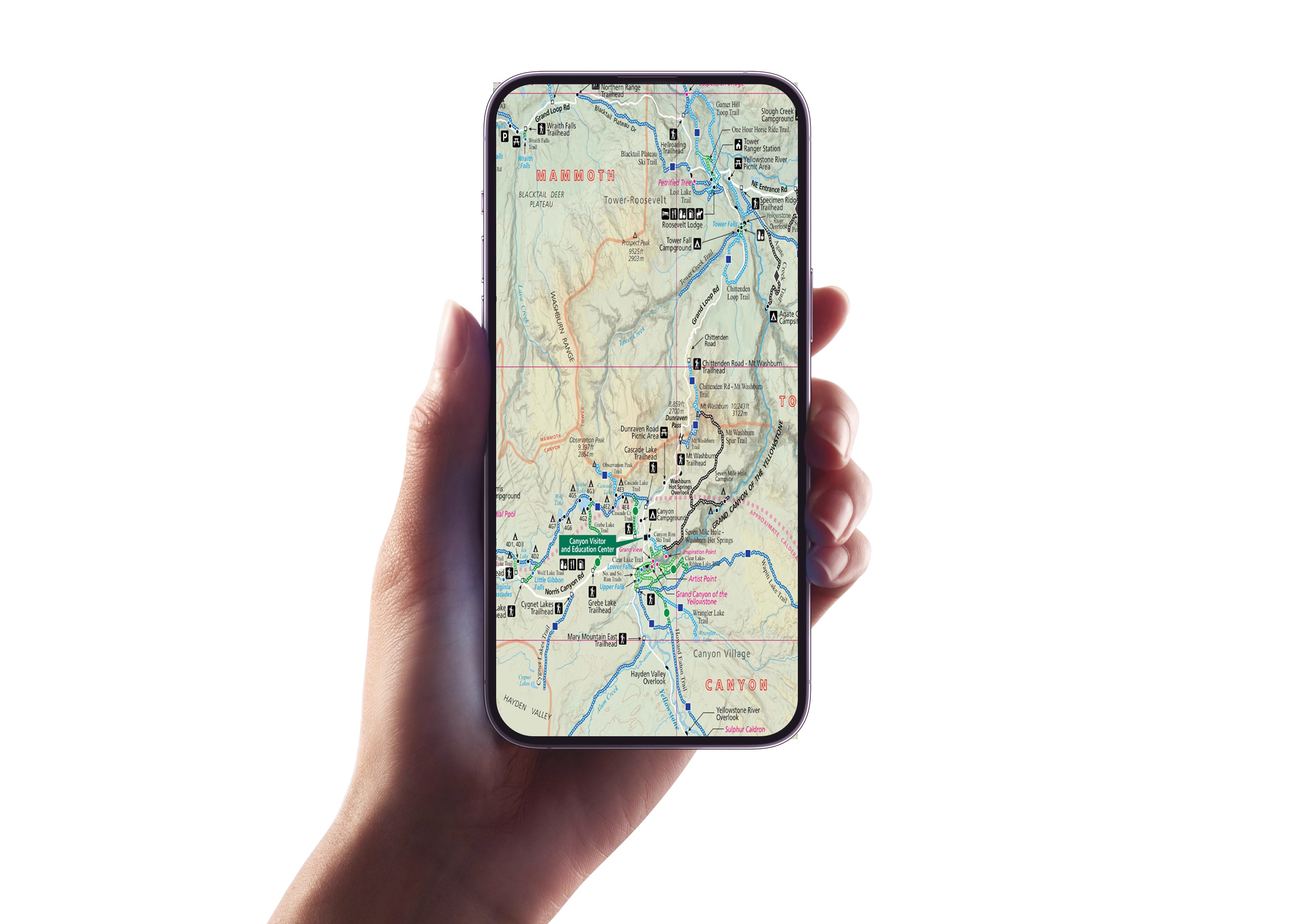
A QR code unlocks the GPS version, allowing you to track your location, zoom in for backcountry precision, and navigate offline—perfect for areas with no cell service.
Retailers: A Proven Grab-and-Go Seller
This map is a must-have for outdoor retailers, park stores, visitor centers, and gear shops throughout the Yellowstone region. Locally designed, field-tested, and packed with real-world value, it’s a product hikers immediately understand—and trust.
Don’t just visit Yellowstone. Know it. Hike it. Discover it. Wander deeper. Climb higher. Discover the wild heart of America’s first national park.
Details
This product is crafted with quality materials to ensure durability and performance. Designed with your convenience in mind, it seamlessly fits into your everyday life.
Shipping & Returns
We strive to process and ship all orders in a timely manner, working diligently to ensure that your items are on their way to you as soon as possible.
We are committed to ensuring a positive shopping experience for all our customers. If for any reason you wish to return an item, we invite you to reach out to our team for assistance, and we will evaluate every return request with care and consideration.